


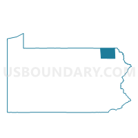
FOREST CITY WD 02, Susquehanna County, Pennsylvania
About
Outline

Summary
| Unique Area Identifier | 663954 |
| Name | FOREST CITY WD 02 |
| County | Susquehanna County |
| State | Pennsylvania |
| Area (square miles) | 0.54 |
| Land Area (square miles) | 0.54 |
| Water Area (square miles) | 0.01 |
| % of Land Area | 98.40 |
| % of Water Area | 1.60 |
| Latitude of the Internal Point | 41.65920910 |
| Longtitude of the Internal Point | -75.46878740 |
Maps


Graphs
Select a template below for downloading or customizing gragh for FOREST CITY WD 02, Susquehanna County, Pennsylvania


Neighbors
Neighoring Voting District (by Name) Neighboring Voting District on the Map
- CLIFFORD TWP Voting District, Susquehanna County, PA
- CLINTON TWP VTD 02, Wayne County, PA
- FOREST CITY WD 01, Susquehanna County, PA
Top 10 Neighboring County Subdivision (by Population) Neighboring County Subdivision on the Map
- Clifford township, Susquehanna County, PA (2,408)
- Clinton township, Wayne County, PA (2,053)
- Forest City borough, Susquehanna County, PA (1,911)
Top 10 Neighboring Place (by Population) Neighboring Place on the Map
Top 10 Neighboring Unified School District (by Population) Neighboring Unified School District on the Map
Top 10 Neighboring State Legislative District Lower Chamber (by Population) Neighboring State Legislative District Lower Chamber on the Map
Top 10 Neighboring State Legislative District Upper Chamber (by Population) Neighboring State Legislative District Upper Chamber on the Map
Top 10 Neighboring 111th Congressional District (by Population) Neighboring 111th Congressional District on the Map
Top 10 Neighboring Census Tract (by Population) Neighboring Census Tract on the Map
- Census Tract 329.01, Susquehanna County, PA (4,342)
- Census Tract 9603, Wayne County, PA (2,303)
- Census Tract 329.02, Susquehanna County, PA (1,911)